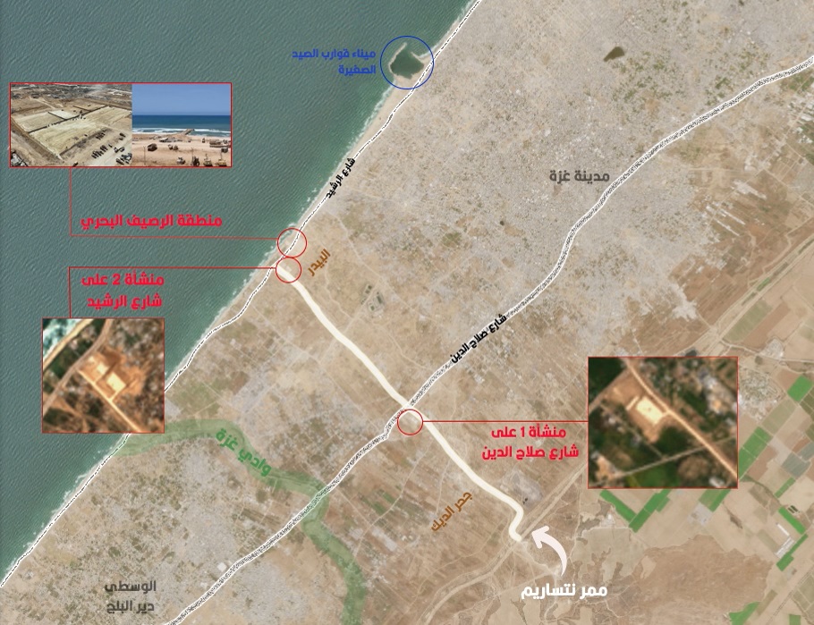
The newspaper noted that “the bases allow for the residence of hundreds of soldiers, who now belong to two reserve brigades”, explaining that some of these forces “will also be responsible for securing the construction of the maritime pier by the American army on the coast of the sector”.
According to the newspaper, two large barracks have been provided to the permanent sites for operational communications, along with dozens of gathering, surveillance, and imaging devices, which are managed around the clock throughout the week.
The newspaper also indicated that soldiers experienced cellular reception in some Israeli networks in the Netzarim corridor, despite the fact that ground troops are prohibited from bringing mobile phones into the area on the western side of the corridor, which is eight kilometers long, near the beach.
The occupation army is currently working to complete major crossing routes with remote inspection devices, especially cameras equipped with facial recognition technology, to immediately facilitate the return of hundreds of thousands of displaced persons from Gaza from shelters in southern Gaza to their homes. In the north – a key bargaining chip in the prisoner exchange deal with the resistance.
Last March, satellite images showed that the occupation army began building a road dividing the Gaza Strip into two sections ending at the shores of the Mediterranean, according to the American network “CNN”.
The name “Netzarim” has spread in Israel, based on a former Israeli settlement in the Gaza Strip with the same name.
Where is the Netzarim corridor located, and what is its purpose? The “Netzarim corridor” or “Route 794” extends for more than 6 kilometers, from the separation line between Gaza and the settlements of the buffer zone east of the sector to the coast westward.
Construction of the corridor began by establishing a road dividing the Gaza Strip into two sections, from the east of the Nahal Oz area to the west of the coastal Beddoura area.
This area is located west of Gaza City, in the eastern area overlooking the eastern Gaza Valley, which in turn separates the sector geographically, thus drawing a military line separating northern Gaza from its south, following the forced displacement operations carried out in the northern part of the sector.

The occupation forced residents in northern Gaza to evacuate southward after implementing fiery belts and a ground invasion, resulting in committing large and multiple massacres against civilians since the beginning of the war, and referring it to the International Court of Justice on charges of committing genocide.
At the end of the Netzarim corridor towards the beach, lies the maritime tongue established by the US army and the “World Kitchen” foundation since April 1, 2024. On the 28th of the same month, Israeli army spokesperson Avichay Adraee announced through his “X” account, the participation of the Israeli army in the operations of the floating maritime pier, which was planned to be connected to the maritime tongue, to deliver humanitarian aid by sea to northern Gaza.
The Israeli army established the Netzarim corridor on March 1, 2024, to pave a new path, at the expense of Palestinian infrastructure, buildings, and lands, after bombing and destroying them.
Sunna Files Free Newsletter - اشترك في جريدتنا المجانية
Stay updated with our latest reports, news, designs, and more by subscribing to our newsletter! Delivered straight to your inbox twice a month, our newsletter keeps you in the loop with the most important updates from our website


