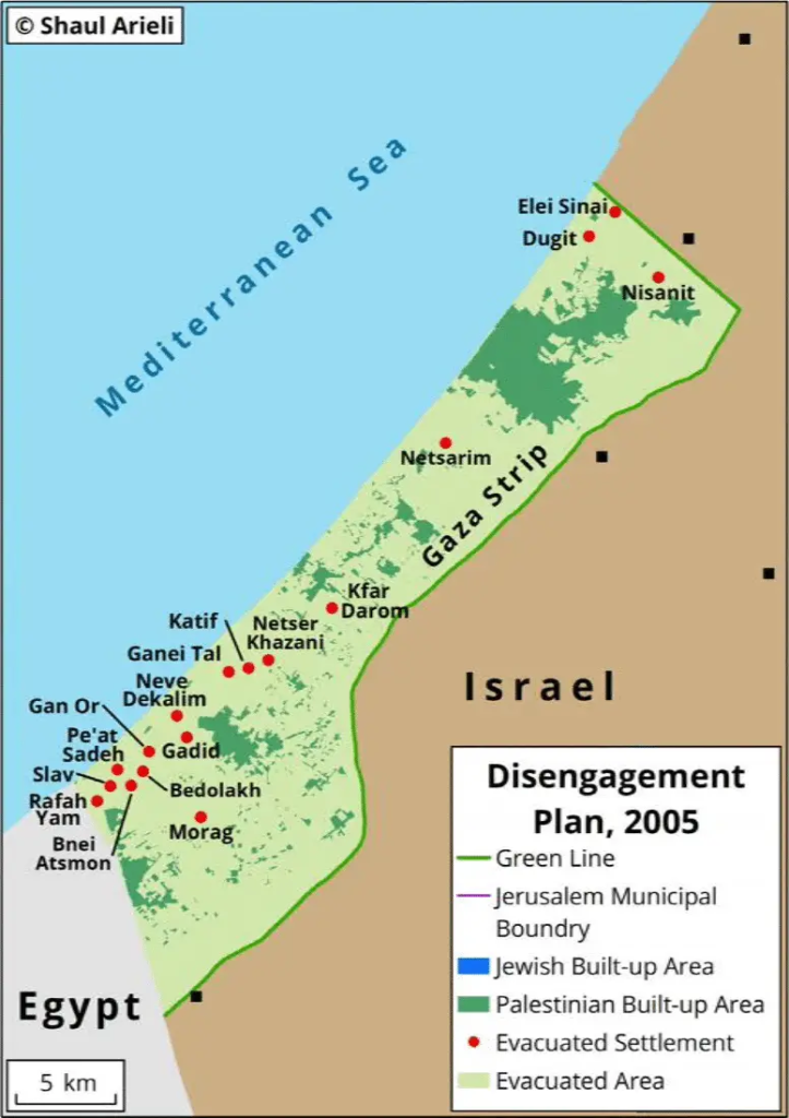
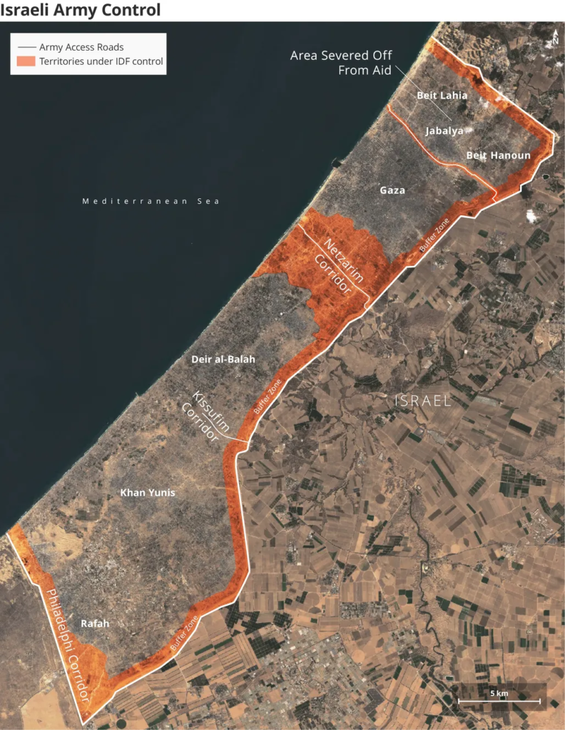
Despite Israel’s failure to officially announce its final plan for the aftermath of the war on Gaza, its actions reveal a strategy to divide the Gaza Strip into separate land axes, each with its own crossing point. This move signals a step toward imposing an Israeli military rule over the region.
In June 2023, The Wall Street Journal reported that one of the plans discussed by the Israeli government was the “Bubble Plan.” This plan aimed to create separate, controllable zones for Palestinians unassociated with Hamas. However, this plan, coupled with Israel’s current actions of splitting Gaza into sections, strongly resembles former Israeli Prime Minister Ariel Sharon’s “Finger Plan,” which led to settlements and roads that divided Gaza prior to Israel’s withdrawal in 2005.
What Is the Finger Plan?
In 1971, Ariel Sharon, then the commander of the southern region in the Israeli army, presented the “Finger Plan” to the Ministerial Committee for Settlement Affairs during the tenure of Golda Meir’s government. The plan aimed to tighten Israeli control over the Gaza Strip.

Standing atop the sand dunes where the settlement of Netzarim was later established, Sharon outlined his strategy for what he called “eliminating terrorism,” requiring three key components:
-
- Military superiority
-
- Jewish settlement
-
- Rehabilitation of Palestinian refugee camps
This old plan (the Finger Plan) divided Gaza into four parts, forming five “fingers” stretching from north to south.
-
-
First Finger (North Gaza):Included three settlement blocs: Elei Sinai, Nissanit, and Dugit, with the goal of expanding Ashkelon’s reach to the borders of Beit Hanoun.
-
-
-
Second Finger (Netzarim Axis):Proposed the establishment of a road connecting Netzarim to Nahal Oz, separating Gaza City from refugee camps in the central Gaza Strip.
-
-
-
Third Finger (Kisufim Axis):Divided the area of Deir al-Balah and surrounding refugee camps from the cities of Khan Yunis and Rafah. Settlements along this axis included Kfar Darom and the Gush Katif bloc.
-
-
-
Fourth Finger (Sufa Axis):Stretched between Khan Yunis and Rafah via the Sufa Axis, hosting several settlements south of Gush Katif.
-
-
-
Fifth Finger (Philadelphi Axis):Separated Rafah from Egypt’s Sinai Peninsula. Following the 1979 peace treaty between Israel and Egypt, the Philadelphi Route was established as a buffer zone.
-
Is Israel Reviving the Finger Plan in Gaza?
The Israeli army has already begun implementing a division of the Gaza Strip, mirroring the Finger Plan. Israeli newspaper Haaretz has reported on Israel’s intention to reoccupy Gaza, dividing it into four distinct sections.

-
-
Netzarim Axis:Israel established this axis to separate the northern region of Gaza and Gaza City from the rest of the Strip. This axis, forming Sharon’s “second finger,” now spans 8 kilometers in width and 7 kilometers in length, covering 56 square kilometers (15% of Gaza’s total area). Infrastructure such as roads, military outposts, and utilities is being expanded, hinting at future settlement plans.
-
-
-
Philadelphi Axis:In May 2024, the Israeli army took control of Rafah and the Philadelphi Route, isolating Gaza from external connections. Extensive destruction in Rafah has occurred as part of Israel’s expansion efforts in this area. Israel claims its actions are aimed at preventing arms smuggling via tunnels beneath the route.
-
-
-
Maflasim Axis:A new route, Maflasim, now separates North Gaza from Gaza City, effectively fragmenting the northern section into two isolated areas. Reports indicate that Israel is actively working to depopulate this region, aligning with previously criticized military strategies.
-
-
-
Kisufim Axis:Recently reopened, Kisufim connects central Gaza with humanitarian aid channels, though its role mirrors that of the third “finger” from Sharon’s original plan. The surrounding area has seen widespread destruction, and Israel has built a fortified pathway leading west to the coast.
-
Limited Movement in Gaza’s Fragmented Areas
After completing these divisions, over 2 million Palestinians are confined to isolated bubbles within Gaza. Movement between these areas is restricted by Israeli checkpoints and crossings, further limiting freedom.
Currently, there are four primary crossings:
-
- Erez Crossing: Located northwest of Gaza, serving the northern section.
-
- Kerem Shalom Crossing: Situated southeast, near Rafah.
-
- Kisufim Crossing: Recently reopened near Deir al-Balah.
-
- Karni Crossing: East of Gaza City, connecting the north and center.
Israeli sources suggest an additional crossing might be opened soon.
Will Israel Leave Gaza Soon?
While Haaretz reports that Israeli forces may remain until 2026, other media speculate that Israel has no intention of withdrawing in the near future. Military presence across buffer zones and key locations suggests a long-term strategy.
Two potential scenarios are being discussed:
-
- Israeli Military Governance: A practical but resource-intensive option.
-
- Deliberate Chaos: Maintaining the current fragmented reality to avoid full reoccupation.
In recent weeks, Israel has also engaged private companies to manage humanitarian aid in Gaza, further solidifying its control over the Strip.
Sunna Files Free Newsletter - اشترك في جريدتنا المجانية
Stay updated with our latest reports, news, designs, and more by subscribing to our newsletter! Delivered straight to your inbox twice a month, our newsletter keeps you in the loop with the most important updates from our website


